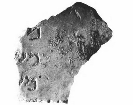
The 24 priestly divisions of the Caesarea Inscription
The whereabouts
In the 10th century BCE, King David initiated the management of the priesthood for its establishment in the future temple his son Solomon will build.
David, "with Zadok of the sons of Eleazar and Ahimelech of the sons of Ithamar, divided them according to their offices for their ministry." (1 Chr 24: 3). He ordered 24 priests divisions to officiate in this temple, each one according to periods in the calendar.
And David told his son Solomon,
"Now behold, there are the divisions of the priests and the Levites for all the service of the house of God, and every willing man of any skill will be with you in all the work for all kinds of service. The officials also and all the people will be entirely at your command.”
1 Chr 28:21
Then, when the Temple was built,
"Now according to the ordinance of his father David, he [Solomon] appointed the divisions of the priests for their service, and the Levites for their duties of praise and ministering before the priests according to the daily rule, and the gatekeepers by their divisions at every gate; for David the man of God had so commanded."
2 Chr 8:14
[word in bracket mine]
This temple was destroyed centuries later, in 586 BCE, during the siege of Jerusalem, by order of Nebuchadnezzar the king of Babylon, when God had con-demned His people because of their transgressions. This destruction was followed by an exile to Babylon while many were killed in the land.
(2 K 25:8-11; Jer 7:30-34; 25:8-11)
Then, when they returned to their homeland Israel, Zerubbabel began the construction of a second temple, which was completed in 516 BC. Centuries later Herod extended it. Jesus prophesied its destruction and it happened in 70 AD when the Roman army sacked the city. The Simon Bar Kokhba revolt against Roman presence ended in 135 CE, and Jews which were not killed were banned from Jerusalem.
It seems that a reorganization of the priesthood was prepared, in the hope of a new temple to come. Families of priests fled to the Galilee a time after this revolt. Twenty-four priestly families were assigned to cities in this region, with synagogues in which they officiated their priesthood, King David having formerly ordained twenty-four priestly divisions, which were to be kept all along the following generations.
Wiki/Priestly Divisions:
" Eleazar ben Killir, also wrote a liturgical poem detailing the 24-priestly wards and their places of residence. Historian and geographer, Samuel Klein (1886–1940), thinks that Killir's poem proves the prevalence of this custom of commemorating the courses in the synagogues of Erez Israel. The purpose of composing these lists was to keep in living memory the identities and traditions of each priestly family, in hopes that the Temple would be quickly rebuilt."
Now, the names of the Caesarea inscription are in the same numerical order as from times past.
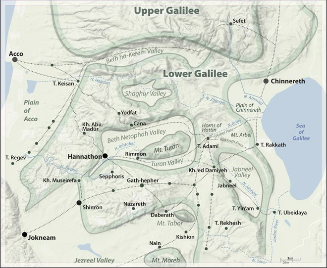
We have seen in the Har Nitai as Nazareth page, that they settled "from Aithalu in the north to Beth-Yerah in the south".
Ancient Synagogues - Archaeology and Art: New Discoveries and Current Research, by Rachel Hachlili.
"The priestly courses list is a disputed historical issue in regard to the transfer of priestly families to the Galilee during the Mishnaic period, and its date is
in debate: Trifon [...] maintains that the list of the priestly courses belongs to the second part of the 3rd century CE, in concert with the increase in the settle-ments of priests in the Galilee; [...] it also suggested "that a large number of priests settled in the Galilee as a result of the immigration of Jews, including pri-ests, from the Diaspora."
[bracketed ellipses mine]
A Roadmap to the Heavens: An Anthropological Study of Hegemony Among Priests ... by Sigalit Ben-Zion
"There is a consensus among scholars that there was a high rate of immigration of priestly families to the Galilee after the destruction of the Temple.[...] Nevertheless, scholars disagree as to whether the great immigration of priestly courses began after the Great Revolt, [...] after the Bar-Kojhba Revolt, or during the third century (Trifon 1990)."
The author argues that " the great immigration of the priestly courses occurred after the Bar-Kokhba Revolt. It should be expressly noted that the main concern is to point out that the immigration of the priestly courses to the Galilee is an important indication that the Priests continued to exist as a social group after the destruction of the Temple."
"Furthermore, the archaeological examination reveals that the character of the priestly courses is not homogeneous, as in the period of the Second Temple. Some of the priestly families chose to reside in separate settlements, while other priestly courses, who were great in number, preferred to settle close to the suburb. Most of these Priests were probably engaged in agriculture and cattle breeding, especially the priestly families who resided in fertile areas like the valley of Beit-Netufa, whereas others were engaged in different crafts such as pottery, like the priestly families who lived in Sochin and Chozpit [...]."
[bracketed ellipses mine]
The names mentioned in this list of 24 priestly courses dating of the 3rd or 4th centuries C.E. (according to archaeological data) are not necessarily the na-mes of 24 priests in this period, rather the names of priestly orders, having as their origin the priests ordained by King David in his time, for ministering in the temple built later by his son Solomon.
As we can see concerning Zacharias, the husband of Elisabeth and father of John the Baptist:
"In the days of Herod, king of Judea, there was a priest named Zacharias, of the division of Abijah; and he had a wife from the daughters of Aaron, and her name was Elizabeth.
. . . . . . . . . .
Now it happened that while he was performing his priestly service before God in the appointed order of his division, according to the custom of the priestly office, he was chosen by lot to enter the temple of the Lord and burn incense." Luke 1: 5,8,9
Therefore, in all generations since David (1 Chr. 24:10), this division of Abijah was the 8th priestly course, even in time of the priest Zacharias, and then later, when the priestly courses moved to the Galilee.
The list of 24 priestly divisions
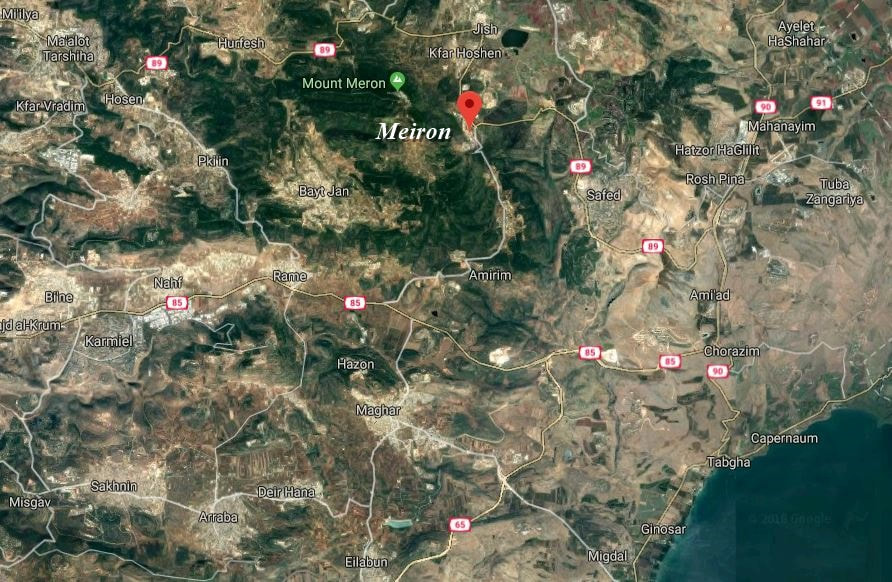
1. The course of Jehoiarib: Meiron
In the Caesarea Inscription:
Current spelling: מירון
In Google Maps satellite ( N 32°59′16″ E 35°26′27″ )
In Google Maps satellite ( N 32°59′16″ E 35°26′27″ )
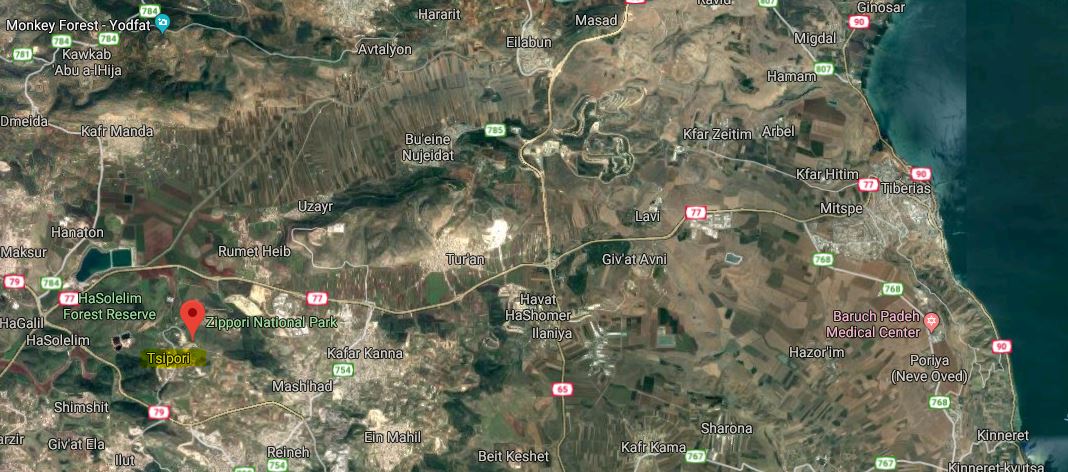
2 . The course of Jed'aiah 'Amok': Sepphoris
In the Caesarea Inscription::
Current spelling: צפורי (Tsipori)
In Wikipedia:
" Following the Bar Kokhba revolt of 132–135, Sepphoris was one of the centers in Galilee where rabbinical families from Judea relocated. Remains of a synagogue dated to the first half of the fifth century were discovered on the northern side of town "
In Google Maps satellite ( N 32°45′12″ E 35°16′45″ )
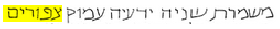
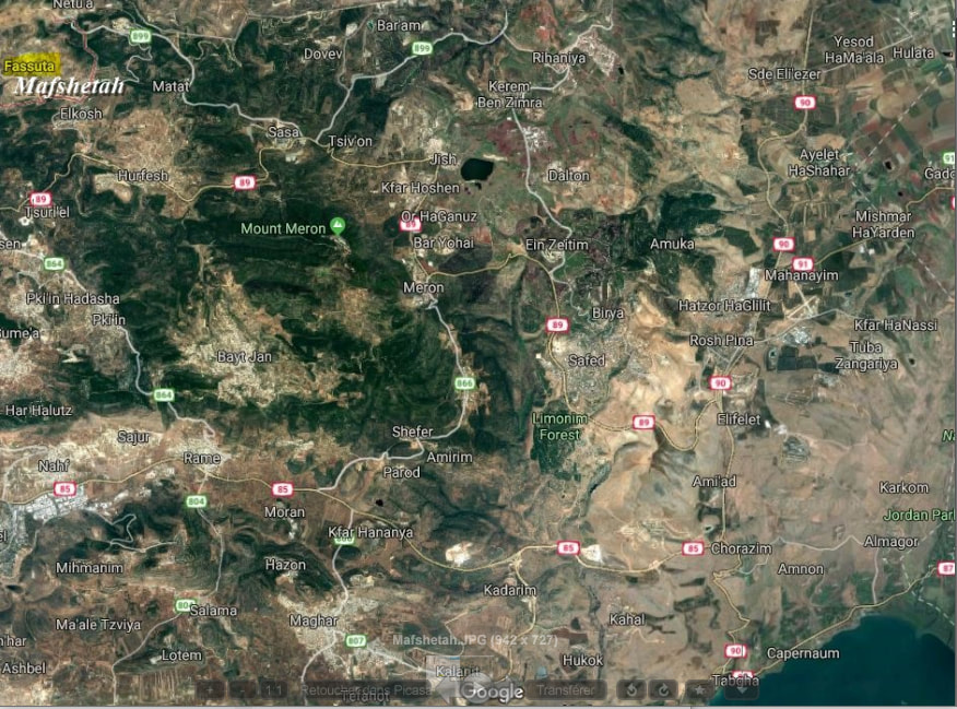
3. The course of Harim: Mafshetah
In the Caesarea Inscription:
The current city is Pasuta, of Fassuta. In Geonames, we find one of its alternative names, Mafshatah.
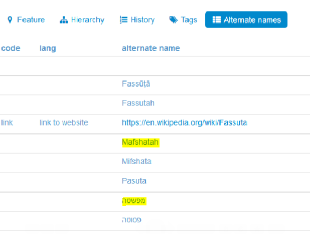
In Google Maps satellite ( N 33°02′56″ E 35°18′32″ )
4. The course of Se'orim: Aithalo
In the Caesarea Inscription:
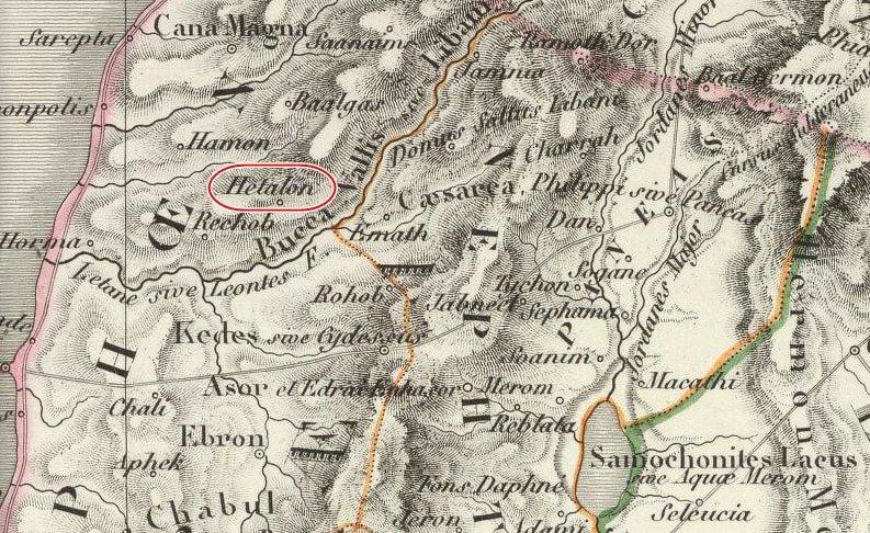
It is not easy to find Aithalo. A text says, concerning the priest families who fled Judea following the revolt of Bar Kokhba, that they settled "from Aithalu in the north to Beth-Yerah in the south". It might be the Hethlon of Ezekiel 47:15-17. Spelled 'Hethalon' in old maps, it is shown in the far northern Galilee.
“This shall be the boundary of the land: on the north side, from the Great Sea by the way of Hethlon, to the entrance of Zedad; Hamath, Berothah, Sibraim, which is between the border of Damascus and the border of Hamath; Hazer-hatticon, which is by the border of Hauran. The boundary shall extend from the sea to Hazar-enan at the border of Damascus, and on the north toward the north is the border of Hamath. This is the north side."
Ezekiel 47:15-17 (See also Ez. 48:1)
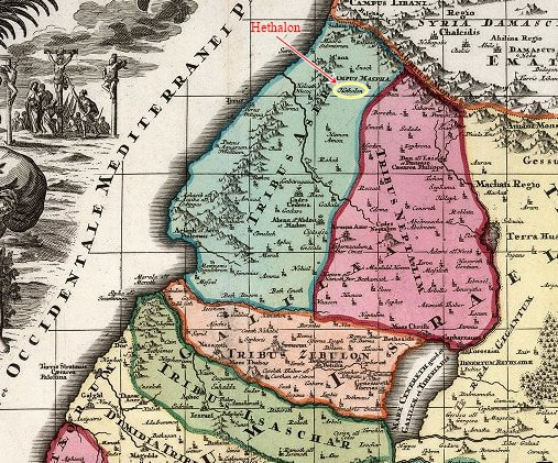
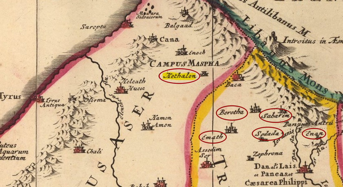
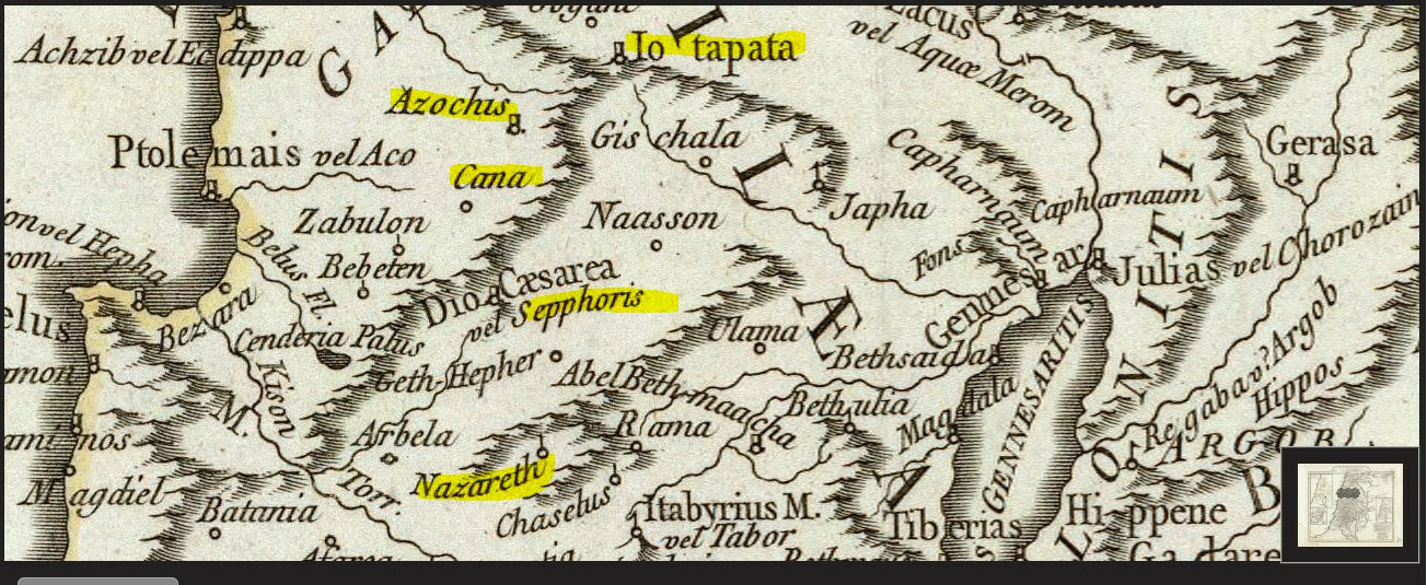
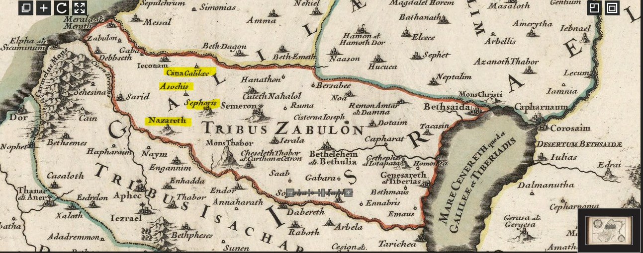
In Ezekiel 47:15-17, we find these cities as well as Hethlon, which are in the same region: Hethalon (as Hethlon), Sedada (as Zedad), Emath (as Hamath), Berotha (as Berothah), Sabarim (as Sibraim), Enan (as Hazar-Enan). Cana, here, seen north of Hethalon, called Cana Major, or Cana Magna, as seen on the map below, is not the Cana known in the New Testament and among the 24 priestly courses, in the Lower Galilee.
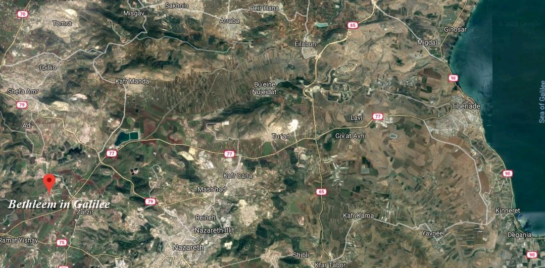
5. The course of Malchijah: Bethleem
A city named Bethleem is present in the Galilee. (Not to confuse with Bethleem in Judea, where our Lord was born.)
In the Caesarea Inscription:

Current spelling: בית לחם
In Google Maps satellite ( 32°44′12″N 35°11′29″E )
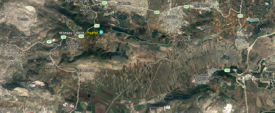
6. The course of Mijamin: Yodfat
In the Caesarea Inscription:
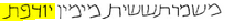
Current spelling: יודפת
In Google Maps satellite ( 32°50'17.0"N 35°16'18.0"E )
In Google Maps satellite ( 32°50'17.0"N 35°16'18.0"E )
7. The course of Hakkoz: Ailbo
In the Caesarea Inscription:
Current spelling: עילבון (Eilabun)
In Google Maps satellite ( N 32°50′13″ E 35°24′01″ )
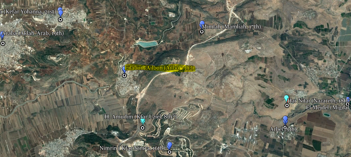
en.wikipedia.org/wiki/Eilabun
Wiki: "Eilabun is mentioned as one of the cities associated with one of the twenty-four priestly divisions, the residence of the priestly clan known as Haqoṣ. A stone inscription mentioning the town was discovered in Yemen by orientalist, Walter W. Muller, in 1970, and is believed to have been part of a ruined synagogue, now turned mosque."
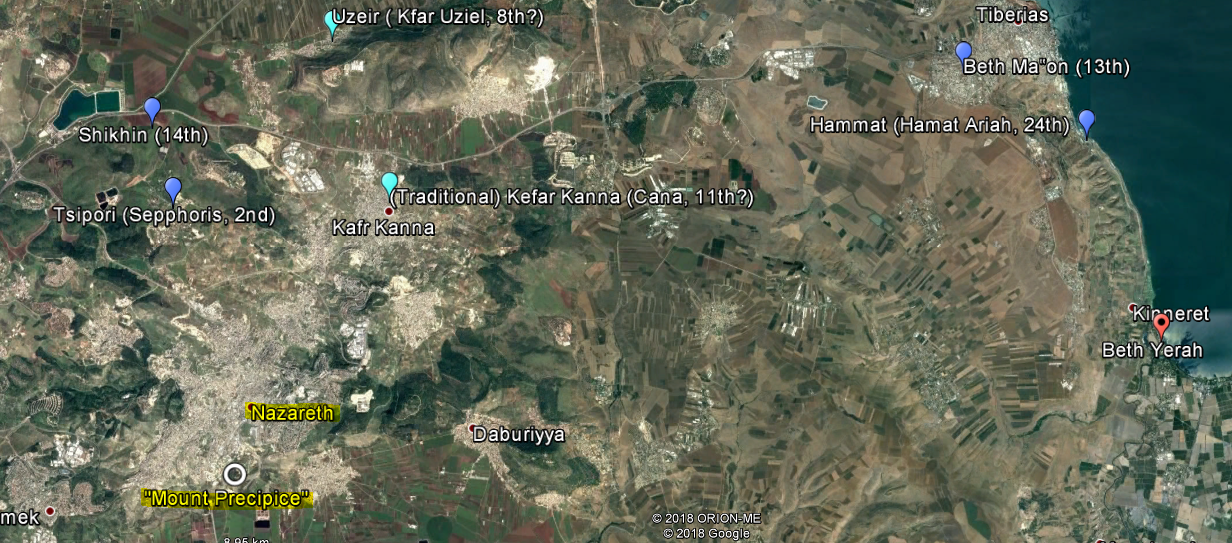
8. The course of Abijah: Kefar Uziel
As we have seen on the main page, the Caesarea Inscription reads Uziah, not Uziel.
In the Caesarea Inscription:
8. The course of Abijah: Kefar Uziel
As we have seen on the main page, the Caesarea Inscription reads Uziah, not Uziel.
In the Caesarea Inscription:

But,
" (...) in 1970 a stone inscription was found on a partially buried column in a mosque, in the Yemeni village of Bayt al-Ḥaḍir, showing ten names of the priestly wards and their respective towns and villages. The Yemeni inscription is the longest roster of names of this sort ever discovered, unto this day, although the seventh-century poet, Eleazar ben Killir, also wrote a liturgical poem detailing the 24-priestly wards and their places of residence. Historian and geographer, Samuel Klein (1886–1940), thinks that Killir's poem proves the prevalence of this custom of commemorating the courses in the synagogues of Erez Israel. The purpose of composing these lists was to keep in living memory the identities and traditions of each priestly family, in hopes that the Temple would be quickly rebuilt." wikipedia/Priestly divisions
[bracketed ellipses mine]
The name Kefar Uziel, spelled as such, has been found in this stone inscription: אֲבִיָּה עדו כפר עוזיאל משמר "Aviah ‘Iddo, Kefar ‘Uzziel, the (eighth) ward"
Speaking of Khirbet Amudim (or Ammudim), a place situated east of the Valley of Netofah, Levine mentions,
"It has been suggested that this site should be identified with Kefar 'Uziel mentioned in rabbinic sources. Kefar 'Uziel was the seat of the Abia [Abijah] 'Iddo clan, one of the twenty-four priestly courses which settled in Eastern Galilee during the late first or second centuries C.E. following the disruptions in Judea."
Ammudim, in Hebrew: Pillars (plural of Ammud)
The Arabic name of the place is Umm el 'Amed ("Mother of the Column")
wiki/Hurvat Amudim
" The name derives from the columns that once supported the roof of the synagogue and that remained standing.
G. Dalman suggested identifying the site with Kefar Uzziel, mentioned in rabbinical sources and home to one of the 24 priestly families that settled in the Galilee from the 2nd century CE onward, owing to the similar sounding name of the nearby Arab-village, Uzeir (believed to be a corruption of "Uzziel"). The town was abandoned in the late 4th century.
A synagogue, one of the largest in the Galilee (25 x 14 meters), was built at the end of the 3rd century or the beginning of the 4th century."
Here are the few proposals, in red dots:
In Geonames, an alternative name of Horbat Uza ( חרבת עוצה ) is Horbat Utsa.
As seen on this map above, Qever (or Kever) Uziel, which signifies 'tomb of Uziel' (red dot, top of the map), is located to the north of Safed and east of Meiron, close to Amuka. There are no remains of a city or village around (the meaning of Kefar Uziel כפר עוזיאל is "village of Uziel").
" Amuka was established in 1980 on land of the Palestinian village of Ammuqa, became depopulated in the 1948 Arab–Israeli War. It is located about 1 km southeast of the site of Ammuqa." Wiki Amuka
" Ammuqa (also transliterated Amuqa and Amuka) was a village, located five kilometres northeast of Safed ."
" Known locally for its seven springs, Ammuqa also enjoyed renown as the site of the sepulchre of Jonathan ben Uzziel " Wiki Ammuqa
" Rabbi Yonatan Ben Uziel was a student of Hillel the Elder and lived in the first century A.D. " Encyclopedia of Kivrei Tzadikim
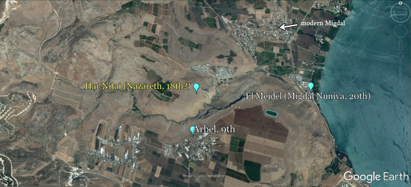
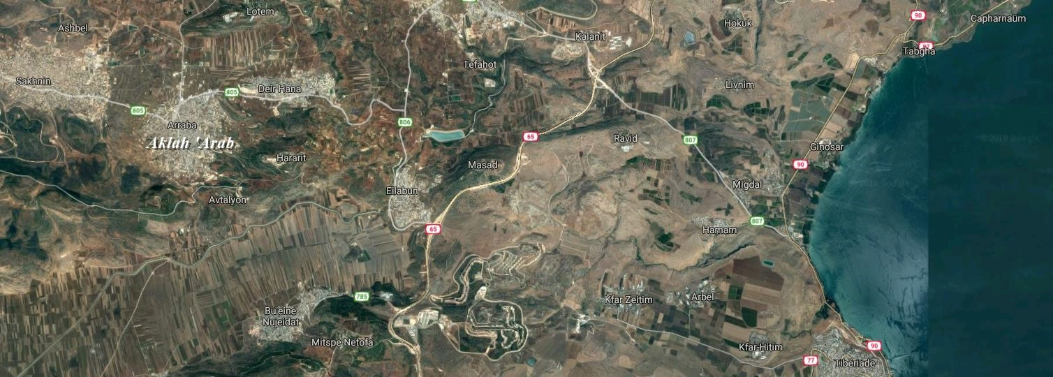
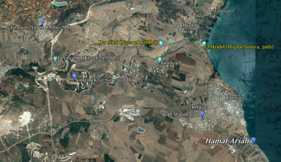
9. The course of Jeshuah: Arbel
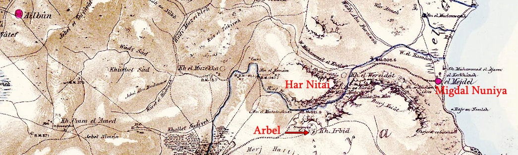
It is obvious that Arbel, very close to Har Nitai, could not have been, despite its impressive cliffs, the city of Nazareth in which Jesus grew up.
Arbel and Nazareth are 2 different priestly courses in the list, the 9th and the 18th, respectively. The cliff of Arbel is to the east of Nitai. The ancient synagogue, with the archaeological site, is more to the south.
In the Caesarea Inscription:
9. The course of Jeshuah: Arbel
It is obvious that Arbel, very close to Har Nitai, could not have been, despite its impressive cliffs, the city of Nazareth in which Jesus grew up.
Arbel and Nazareth are 2 different priestly courses in the list, the 9th and the 18th, respectively. The cliff of Arbel is to the east of Nitai. The ancient synagogue, with the archaeological site, is more to the south.
In the Caesarea Inscription:

Current spelling: ארבל
In Google Maps satellite ( N 32°48′45″ E 35°29′11″ )
In Google Maps satellite ( N 32°48′45″ E 35°29′11″ )
10. The course of Shecaniah: Kabul
In the Caesarea Inscription

Current spelling: כבול
In Google Maps satellite ( N 32°52′07″ E 35°12′42″ )
11. The course of Eliashib Kohen: Qana
In the Caesarea Inscription:

Current spelling: קנה
In Google Maps satellite:
Kafr Kanna (traditional) ( N 32°44′48″ E 35°20′33″ )
Khirbet Qana (N 32°49′20″ E 35°18′10″)
In Google Maps satellite:
Kafr Kanna (traditional) ( N 32°44′48″ E 35°20′33″ )
Khirbet Qana (N 32°49′20″ E 35°18′10″)
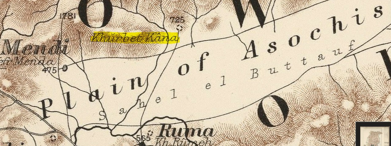
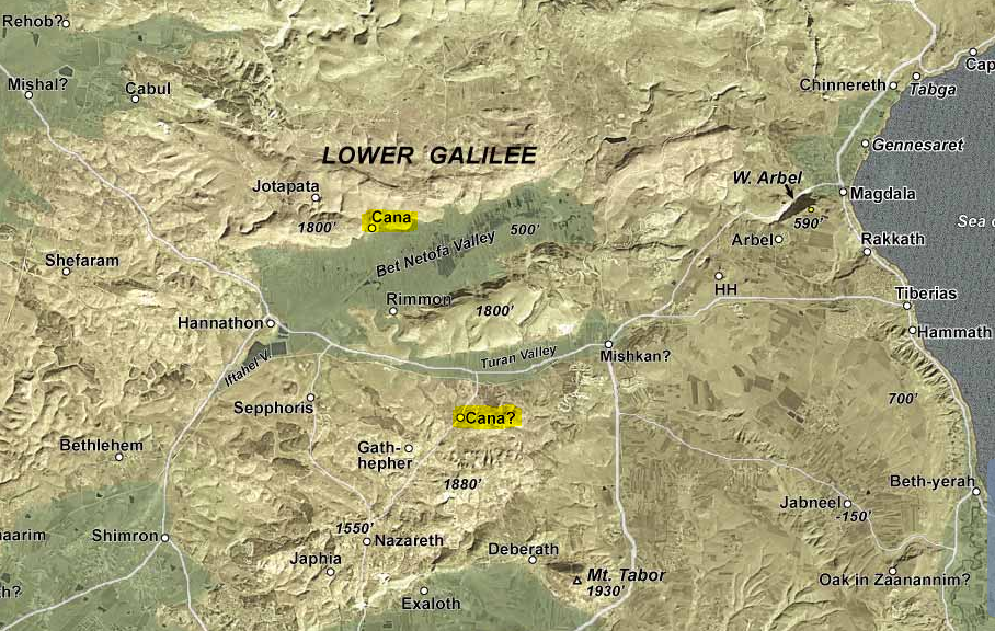
There are 2 places called Cana in the Lower Galilee. One is north-east of and close to the traditional Nazareth, just south of the Turan valley, and is called Kefar Kanna, which means "village of Kanna"; the other is on the northern border of the Beit Netufah valley, and is called Khirbet (or Horbat) Qana, which means "ruin of Qana".
Concerning Khirbet Qana, here is what the International Standard Bible Encyclopedia says:
" Other villages of the same name are mentioned by Josephus, but probably this one is intended by the Cana where for a time he dwelt (Vita, 16) which he lo-cates in the plain of Asochis (ibid., 41). The Greek kana probably transliterates an old Hebrew qanah, "place of reeds." This ancient name survives in Khirbet Qana, a ruined site with rockhewn tombs, cisterns and a pool, on the northern edge of Sahl el-Battauf, the plain of Asochis. Near by are marshy stretches where reeds still abound: the name therefore is entirely appropriate"
Reminder: Sahl el-Battauf, that is, the plain of Asochis, is the Beit (or Beth, Bet) Netophah Valley.
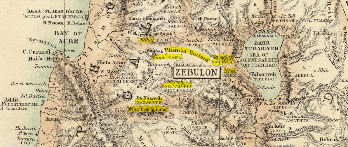
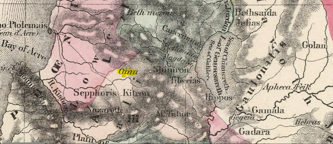
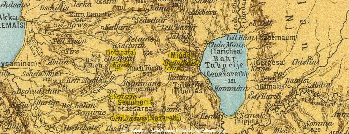
We can see on this map below that Khirbet Qana, called here Cana, is located in the northern border of the Bet Netofa Valley, called Plain of Asochis by Josephus. He mentions Cana as well as this valley, where he had his military quarters. The traditional Cana, noted here with a question mark, situated northeast of the no less traditional Nazareth, is close to and south of the Turan Valley, and not in the borders of the Beit Netofa Valley.
Concerning Khirbet Qana, here is what the International Standard Bible Encyclopedia says:
" Other villages of the same name are mentioned by Josephus, but probably this one is intended by the Cana where for a time he dwelt (Vita, 16) which he lo-cates in the plain of Asochis (ibid., 41). The Greek kana probably transliterates an old Hebrew qanah, "place of reeds." This ancient name survives in Khirbet Qana, a ruined site with rockhewn tombs, cisterns and a pool, on the northern edge of Sahl el-Battauf, the plain of Asochis. Near by are marshy stretches where reeds still abound: the name therefore is entirely appropriate"
Reminder: Sahl el-Battauf, that is, the plain of Asochis, is the Beit (or Beth, Bet) Netophah Valley.
We can see on this map below that Khirbet Qana, called here Cana, is located in the northern border of the Bet Netofa Valley, called Plain of Asochis by Josephus. He mentions Cana as well as this valley, where he had his military quarters. The traditional Cana, noted here with a question mark, situated northeast of the no less traditional Nazareth, is close to and south of the Turan Valley, and not in the borders of the Beit Netofa Valley.
On several ancient maps, the traditional Kfar Kanna is not even mentioned.
Here are a few examples: ( David Rumseys' ancient maps )
Cana, the place in which Jesus changed water into wine at a wedding, is known as Cana of, or in, Galilee. Here are the records:
" On the third day there was a wedding in Cana of Galilee, and the mother of Jesus was there;" John 2:1
" This beginning of His signs Jesus did in Cana of Galilee, and manifested His glory, and His disciples believed in Him." John 2:11
" Therefore He came again to Cana of Galilee where He had made the water wine. " John 4:46
" Simon Peter, and Thomas called Didymus, and Nathanael of Cana in Galilee, and the sons of Zebedee, and two others of His disciples were together."
John 21:2
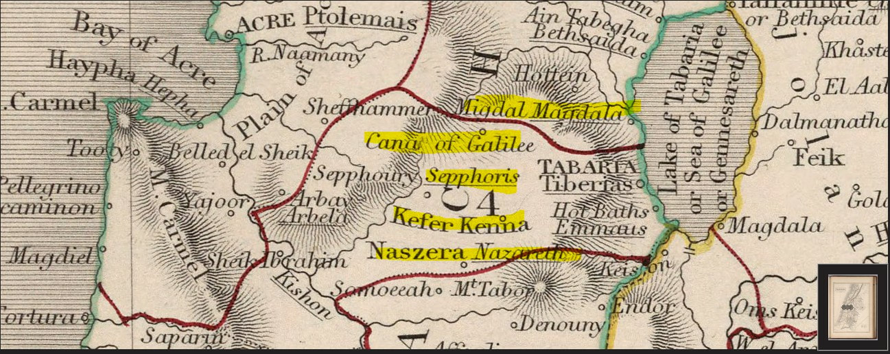
On certain ancient maps, we can even see this town with the same name (in Arabic "Kana el-Jelil" means "Cana of Galilee") when it comes to Khirbet Qana, north of the valley of Beit Netophah (called the plain of Asochis and the plain el Buttauf).
(David Rumsey's maps)
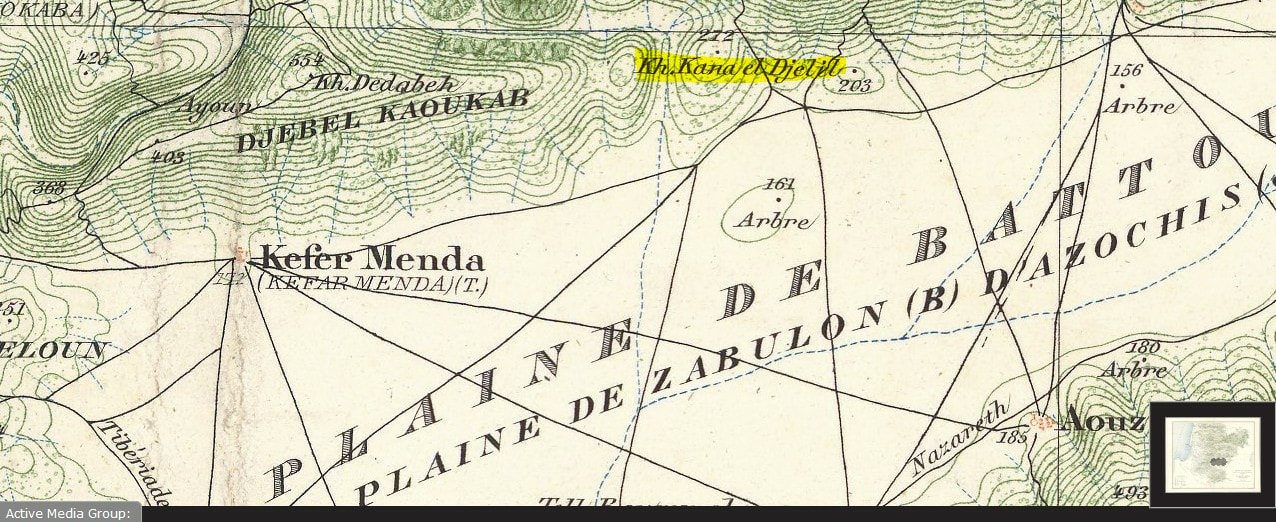
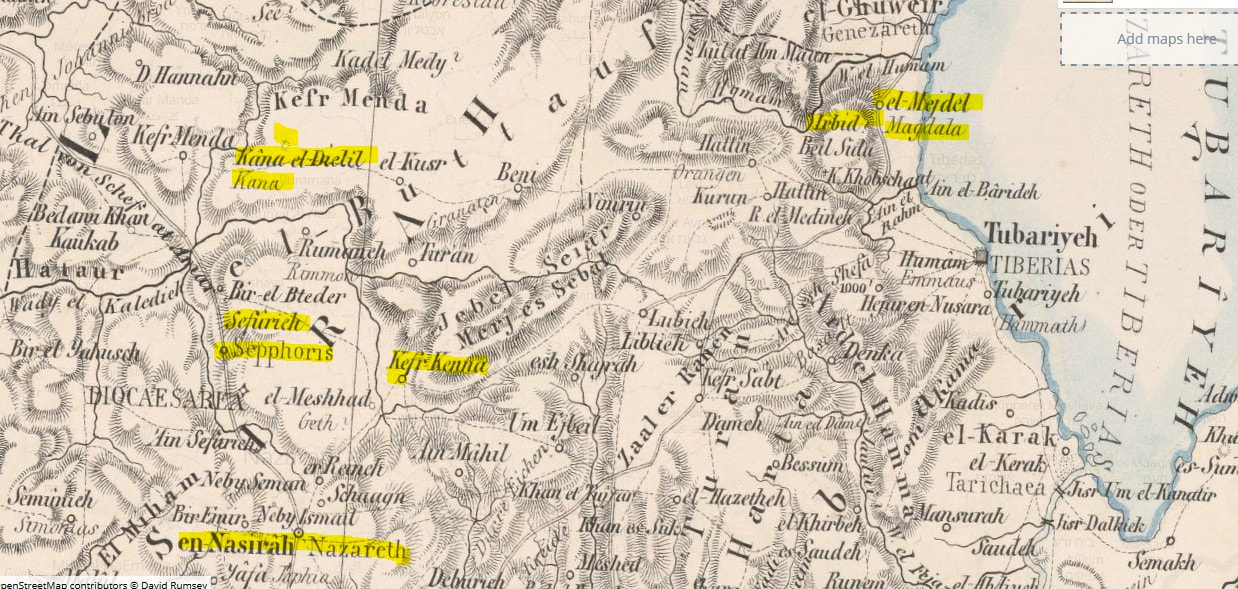
Even on old maps, we can't confuse Kefar Kenna with Khirbet Qana.
The latter is to the north of Sepphoris and to the west of El-Mejdel/Magdala
The latter is to the north of Sepphoris and to the west of El-Mejdel/Magdala
In the book Beth Netofa - Building Jewish in the Roman East of Peter Richardson, we can read:
"The extensive literature describing pilgrimages to the Holyland contains numerous references to Cana, some of which (both in the Byrantine period and in the Crusader period) presuppose that Khirbet Qana was the pilgrim site. Sometime during the Middle Ages attention shifted to Kefr Kenna, today's tourist stop northeast of Nazareth. By the early modern period both sites were known; in the early seventeenth century, Francisco Quaresmius decided between the two sites on the grounds that Kefr Kenna had a church and Khirbet Qana did not. It is likely that an important factor in this shift was that the main road from Sepphoris to Tiberias passed by Kefr Kenna, while Khirbet Qana was not on any major road. Whatever roads may have served it earlier must have gone out of use by the early modern period. It has been argued that a major "Jewish road" went from Tiberias through Arbel, and thence along the north side of the Beth Netofa valley to Cana, at which point the road split, one branch going northwest up the Wadi Yodefat and the other south to Sepphoris. The claim could be correct. Beginning with nineteenth-century investigations of the Holy Land, scholarly opinion has shifted to Khirbet Qana as New Testament Cana, a de-duction now being borne out by excavations begun in 1998."
Francisco Quaresmius was the papal emissary to Palestine. So, it was decided that Kefr Kenna was the right site because there was a church there! And, as well, no important road passed by Khirbet Qana!
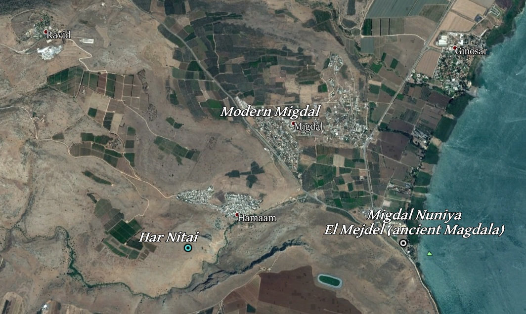
No Scripture speaks about the important city of Sepphoris, though it is close to both traditional Cana (Kefr Kenna) and traditional Nazareth. But Scripture does speak of Tiberias, not far from Har Nitai, which is proposed as being the authentic Nazareth, and from el Mejdel (Migdal Nuniya, the 20th priestly course), which might have been the hometown of Mary Magdalene.
"There came other small boats from Tiberias near to the place where they ate the bread after the Lord had given thanks." John 6:23
Then Peter Richardson even says that it was argued that a major "Jewish road" went from Tiberias through Arbel (which is right next to Har Nitai), and all along the north side of the Beit Netophah valley to Cana; and from there, it was divided. Although there is no need of any argument here in favor of an im-portant road passing by Cana (which became Khirbet Qana, i.e. the ruin of Cana), we even see a road passing by Cana and Yodefat as on this map below:
"The extensive literature describing pilgrimages to the Holyland contains numerous references to Cana, some of which (both in the Byrantine period and in the Crusader period) presuppose that Khirbet Qana was the pilgrim site. Sometime during the Middle Ages attention shifted to Kefr Kenna, today's tourist stop northeast of Nazareth. By the early modern period both sites were known; in the early seventeenth century, Francisco Quaresmius decided between the two sites on the grounds that Kefr Kenna had a church and Khirbet Qana did not. It is likely that an important factor in this shift was that the main road from Sepphoris to Tiberias passed by Kefr Kenna, while Khirbet Qana was not on any major road. Whatever roads may have served it earlier must have gone out of use by the early modern period. It has been argued that a major "Jewish road" went from Tiberias through Arbel, and thence along the north side of the Beth Netofa valley to Cana, at which point the road split, one branch going northwest up the Wadi Yodefat and the other south to Sepphoris. The claim could be correct. Beginning with nineteenth-century investigations of the Holy Land, scholarly opinion has shifted to Khirbet Qana as New Testament Cana, a de-duction now being borne out by excavations begun in 1998."
Francisco Quaresmius was the papal emissary to Palestine. So, it was decided that Kefr Kenna was the right site because there was a church there! And, as well, no important road passed by Khirbet Qana!
No Scripture speaks about the important city of Sepphoris, though it is close to both traditional Cana (Kefr Kenna) and traditional Nazareth. But Scripture does speak of Tiberias, not far from Har Nitai, which is proposed as being the authentic Nazareth, and from el Mejdel (Migdal Nuniya, the 20th priestly course), which might have been the hometown of Mary Magdalene.
"There came other small boats from Tiberias near to the place where they ate the bread after the Lord had given thanks." John 6:23
Then Peter Richardson even says that it was argued that a major "Jewish road" went from Tiberias through Arbel (which is right next to Har Nitai), and all along the north side of the Beit Netophah valley to Cana; and from there, it was divided. Although there is no need of any argument here in favor of an im-portant road passing by Cana (which became Khirbet Qana, i.e. the ruin of Cana), we even see a road passing by Cana and Yodefat as on this map below:
On the same book, Peter Richardson says,
"Later still, Edward Robinson says that "the Cana of the New Testament" is not at Kefr Kenna but rather at a ruin called Kâna el-Jelil, on the northern side of the plain el-Buttauf . . . in the time of Quaresmius, the church and the convent at Nazareth were first built up, after the desolations of many centuries, and this circumstance conspired to give currency among travelers, to the view which monks adopted respecting Cana. Quaresmius's account underscores how a tou-rist preference for Kefr Kenna, the rival site, arose and has been maintained more or less continuously since. The modern turning point was Robinson's use of linguistic criteria to establish the geography of the Holy Land; though his views were strongly contested, they have stood firmly. Recent analyses have confirmed that Khirbet Qana is the site of the Cana of Josephus and the New Testament."
(As a reminder, the meaning of Kâna el-Jelil is "Cana of Galilee")
Tourists chose Kefr (Kefar) Kenna; then it became the popular Cana. So pitiful.
Interesting excavations at Khirbet Qana by the University of Puget Sound do show beyond doubt that the place was inhabited. On their website are the articles about their works:
"Khirbet Qana, A Galilean Village in Regional Perspective" with "Goals and Objectives for Excavation Survey and Excavation, 1997 - 2004".
Open the links in "Khirbet Qana Mapping" page; interesting features of the excavations are shown, with links to Google Earth overlays.
Their Khirbet Qana Galleries are to be seen as well.
See a few pictures of Khirbet Qana (Google search)
Wiki article: "Khirbet Qana is located on a 100-meter hill, on the north side of Beth Netofa valley. Excavations have shown that Khirbet Qana was used as a settlement from the Hellenistic to early Arab period, with housing in use from the Hellenistic period through the Byzantine period. Khirbet Qana was a den-sely populated, but small, rural village that relied mainly on agriculture.
Excavations at Khirbet Qana have revealed that the unwalled city was partially built into the area’s hillsides, resulting in terraced houses on the hill, with larger houses arranged around a courtyard in the flatter areas. Researchers have identified 3 types of houses at Khirbet Qana; terraced housing, side court-yard houses, and central courtyard houses. Terraced houses were located on the steep eastern and western slopes of the hill, while side courtyard houses were located in the flatter area to the north in Khirbet Qana. Courtyard houses were located in the flattest areas of Khirbet Qana, on the hilltop, and featured large central courtyards.
In addition to residential housing, Khirbet Qana includes a Jewish synagogue, a later Byzantine complex (possibly a “veneration cave”), and a series of tombs. There is also some evidence of a monumental building of some kind on the hilltop, perhaps a synagogue, at which a fragment of fresco was found during the excavations of the site. ( Wiki Khirbet Qana )
Here a Google Earth picture of the Khirbet Qana archaeological data of Puget Sound excavations:
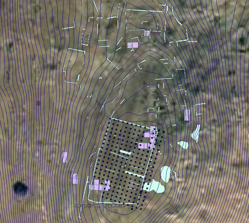
Excavations data of the hill of Khirbet Qana.
12. The course of Pashhur: Safed
In the Caesarea Inscription:

Current spelling: צפת
In Google Maps satellite ( N 32°57′53″ E 35°29′46″ )

13. The course of Huppah: Beth Ma'on
In the Caesarea Inscription:

Current spelling: בית מעון
In Google Maps satellite ( 32°46'57.48"N 35°30'50.02"E )
In Google Maps satellite ( 32°46'57.48"N 35°30'50.02"E )
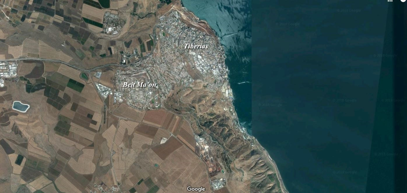
"Bethmaus, or Beth Maʿon (Greek: Βηθμαούς) (Hebrew: בית מעון), was a Jewish village during the late Second Temple and Mishnaic periods, and which was already a ruin (Tell Maʿūn) when Kitchener visited the site in 1877.. It was situated upon the hill, directly north-west of the old city of Tiberias, at a distance of one biblical mile, rising to an elevation of 250 metres (820 ft) above sea-level. It is now incorporated within the modern city bounds of Upper Tiberias. "
(Wiki) Bethmaus,/Beth Maʿon
(Wiki) Bethmaus,/Beth Maʿon
14. The course of Jeshebeab: Shihin
In the Caesarea Inscription:

Current spelling: שִׁיחִין
In Google Maps satellite ( 32.7689°N 35.2733°E )
In Google Maps satellite ( 32.7689°N 35.2733°E )
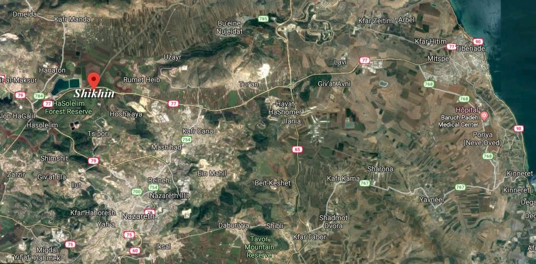
Wiki: "Shikhin (Hebrew:שִׁיחִין), variant spelling (Hebrew: שׁוּחִין), also known as Asochis, was a central Galilean village about 5 miles (8.0 km) northwest of Nazareth that was abandoned in the fourth century AD. As of May 2012, the site is under excavation. So far, evidence of extensive pottery work and a sy-nagogue have been uncovered."
(It is spoken here of the traditional Nazareth)
(It is spoken here of the traditional Nazareth)
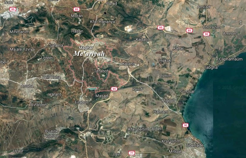
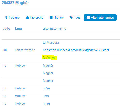
15. The course of Bilgah: Me'ariya
In the Caesarea Inscription:

It is the present city of Maghar.
In Google Maps satellite ( N 32°53′23″ E 35°24′25″ )
16. The course of Imer: Kefar Nimra
In the Caesarea Inscription:

Current spelling: הר נמרה (Har Nimra)
In Google Maps satellite ( N 32°48′30″ E 35°25′28″ )
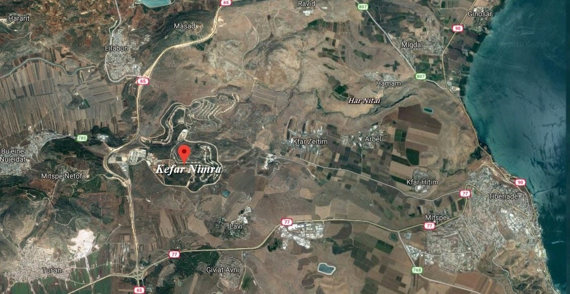
Kefar Nimra is situated with other courses clustered in the same area.
Wiki: "Nimrin stood on the site of Kfar Nimra when Palestine was ruled by the Roman Empire" https://en.wikipedia.org/wiki/Nimrin
"Settlement and History in Hellenistic, Roman, and Byzantine Galilee: An Archaeological Survey of the Eastern Galilee"
De Uzi Leibner
"The village of Nimrin is mentionned in the Ottoman tax census from the end of the sixteenth century (Hutteroth and Abudulfattah 1977: 189) and existed as an Arab village until 1948. Klein (1967: 10) identified this site as Kefar Nimrah, which he cites as appearing in rabbinic litterature, based on the preservation of the name. This identification has been accepted by many researchers."
But there are some controversies about the name of Kefar Nimrah: despite Klein's assertions, Uzi Leibner, the author of this book, says that the name Kefar Nimrah is not mentioned in rabbinic literature, and that its identification with Nimrin lacks textual support.
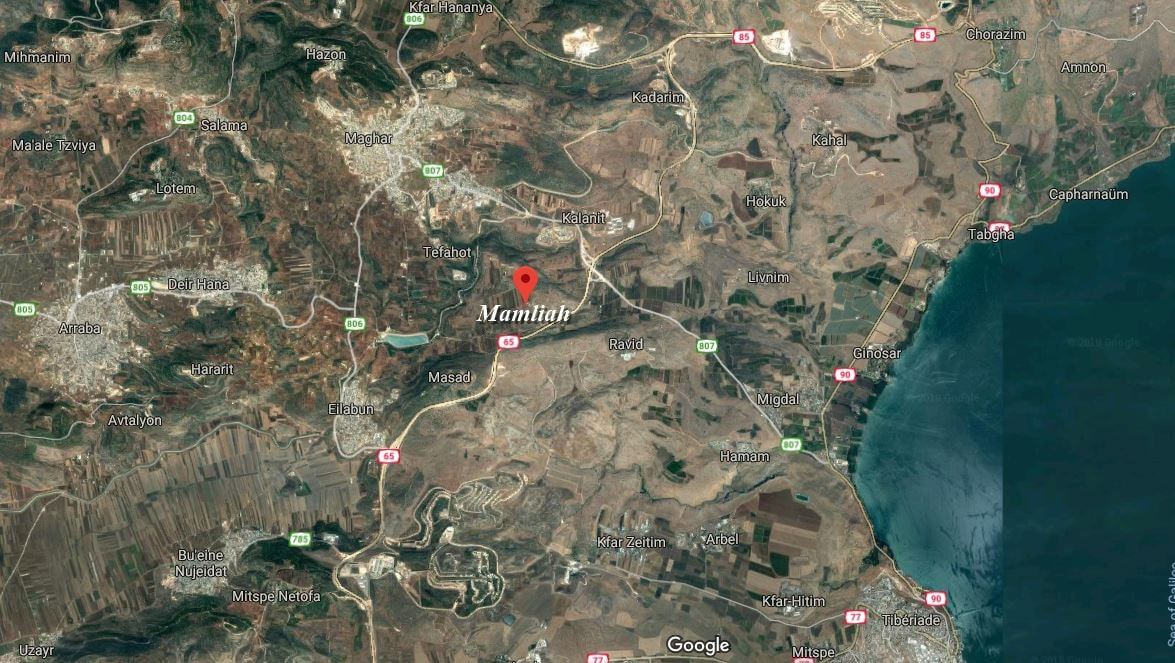
17. The course of Hezir: Mamliah
In the Caesarea Inscription:

Current spelling: ממלח (same spelling - prononced Mimlah)
In Google Maps satellite ( N 32° 51' 25'' E 35° 26' 26'' )
In Google Maps satellite ( N 32° 51' 25'' E 35° 26' 26'' )
18. The course of Hapizzez (Aphses) Nazareth
In the Caesarea Inscription:
In the Caesarea Inscription:

Current spelling: נצרת
In Google Maps satellite
Traditional Nazareth ( N 32°41′57″ E 35°18′17″ )
In Google Maps satellite
Traditional Nazareth ( N 32°41′57″ E 35°18′17″ )
No cliff is present around the "Mount of Precipice" close to the traditional city. Nothing that can corroborate the biblical narrative. Just a place for tourists.
Har Nitai, as a candidate for Nazareth, proposed by Kevin Kluetz. ( 32°49'29.26"N 35°29'4.74"E )
At Capernaum, after the feeding of the five thousand and his walking on the water, Jesus had a discourse with the people. Among them, the Jews were grumbling about him. And they wondered,
“ Is not this Jesus, the son of Joseph, whose father and mother we know? How does He now say, ‘I have come down out of heaven’ ? " John 6:42
If these Jews knew Joseph and Mary, it implies that they lived among the towns and villages around, or not far away from the lake of Tiberias; not at a distance of about 25 miles/40 km. Scripture does not say if the Jews spoken of were inhabitants of Capernaum, but it would be odd that among the people listening to Jesus, "the Jews", not just a few of them, knew Joseph and Mary from the traditional Nazareth, so far away.
Gill's Exposition of the Entire Bible
"[...] for Capernaum and Nazareth were not at a great distance from each other; so that Joseph and Mary might be personally known by the inhabitants of Capernaum, and they might be intimately acquainted with them."
In Scripture, the name Nazareth is spelled as Nazara Ναζαρὰ (2 occurrences), Nazaret Ναζαρέτ (4 occur.) or Nazareth Ναζαρὲθ (6 occur.).
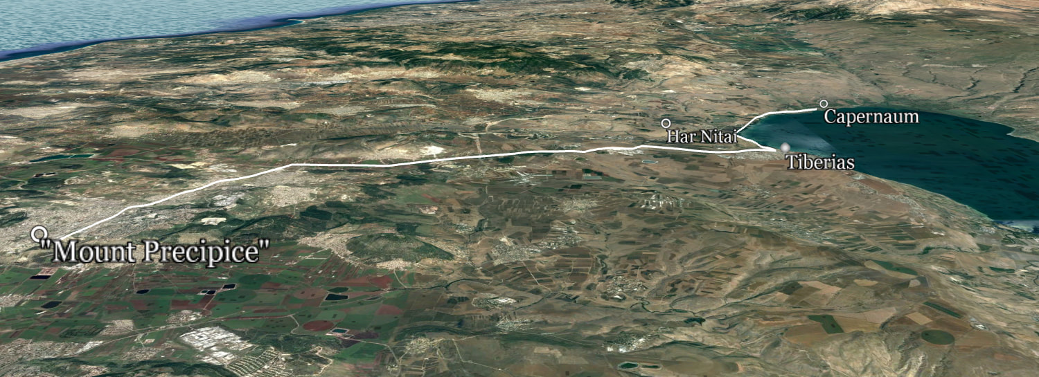
There is at least 25 miles/40 km from the traditional Mount of Precipice to Capernaum.
(about 18 miles/30 km to the Sea of Galilee, in the vicinity of Tiberias and Magdala)
A very long distance, riding a donkey, or by foot.
Har Nitai, as the candidate for Nazareth, is not far from the Sea (3 miles/5 km) and other towns and villages (7.5 miles/12 km from Capernaum).
Joseph and Mary could be known around.
19. The course of Pethahiah: Aklah 'Arab
In the Caesarea Inscription:

Current spelling: ערבה (Araba)
In Google Maps satellite ( N 32° 51' 3'' E 35° 20' 13'' )
20. The course of Jehezekel: Migdal Nuniya
Babylonian Talmud: Magdala Nunayya - Aramaic: מגדלא נוניה (see text below)
In the Caesarea Inscription:

Current spelling: מגדל (Migdal)
In Google Maps satellite ( 32°49'32.70"N 35°30'57.46"E )
In Google Maps satellite ( 32°49'32.70"N 35°30'57.46"E )
Magdala is not mentioned in Scripture; as 'ancient Magdala' I refer here to Magdala Nunayya in the Talmud of Babylon.
Wiki: "In the Babylonian Talmud it is known as Magdala Nunayya (Aramaic: מגדלא נוניה, meaning "Tower of the Fishes [...] Archaeological excavations on behalf of the Israel Antiquities Authority conducted in 2006 found that the settlement began during the Hellenistic period (between the 2nd and 1st centuries BCE) and ended during the late Roman period (3rd century CE). Later excavations in 2009–2013 brought perhaps the most important discovery in the site: an ancient synagogue, called the "Migdal Synagogue". It is the oldest synagogue found in the Galilee, and one of the only synagogues from that period found in the entire country, as of the time of the excavation. They also found the Magdala stone, which has a seven-branched menorah symbol carved on it. It is the earliest menorah of that period to be discovered outside of Jerusalem." [bracketed ellipses mine]
Wiki: "In the Babylonian Talmud it is known as Magdala Nunayya (Aramaic: מגדלא נוניה, meaning "Tower of the Fishes [...] Archaeological excavations on behalf of the Israel Antiquities Authority conducted in 2006 found that the settlement began during the Hellenistic period (between the 2nd and 1st centuries BCE) and ended during the late Roman period (3rd century CE). Later excavations in 2009–2013 brought perhaps the most important discovery in the site: an ancient synagogue, called the "Migdal Synagogue". It is the oldest synagogue found in the Galilee, and one of the only synagogues from that period found in the entire country, as of the time of the excavation. They also found the Magdala stone, which has a seven-branched menorah symbol carved on it. It is the earliest menorah of that period to be discovered outside of Jerusalem." [bracketed ellipses mine]
Some biblical versions read "Mary of Magdala", but the original Greek is "Maria the Magdalēnē".
In the NAS Exhaustive Concordance: Word Origin: fem. of Magdalénos - Magdalene, of Magdala, a place on the coast of the Sea of Galilee near Tiberias.
Jesus called his female disciple 'Mary (the) Magdalen' certainly using a surname, which would mean 'Mary the Tower', as He did for Simon which He called Peter, which means 'Rock'; the same for James the son of Zebedee and John the brother of James which He called 'Boanerges', “Sons of Thunder”, and He gave surnames to others as well.
"While Mary may well have come from Migdal Nuniya, referred to as Magdala by people of the lake, the epithet ‘the Magdalene’ may be understood as meaning ‘the Tower-ess’: a nickname like others Jesus gave to his closest apostles." (see the article "Missing Magdala and the Name of Mary 'Magdalene' ", by Joan E. Taylor (pdf))
(There's also one occurrence for another name, Magadan, in Mat 15:39, " And sending away the crowds, Jesus got into the boat and came to the region [borders, boundaries] of Magadan."
- ὅρια Μαγαδάν (horia Magadan) - ὅριον (horion): the boundaries of a place, hence: district, territory. ( Strong's Concordance #3725 )
"Magadan, an unidentified place near the Sea of Galilee." - NAS Exhaustive Concordance
The Thayer's Greek Lexicon tells us, "If either of these forms was the one used by the Evangelist it could very easily have been changed by the copyists into the more familiar name Μαγδαλά [Magdala]." -
[word in bracket mine]
Magadan may come from the Syriac Magedan and could be another place, different from Migdal Nuniya/Magdala.)
The Times of Israel:
"After seven years of excavations at Magdala, four rare ritual baths and a unique carved stone point to importance of ancient fishing town to priestly class."
(...)
"The hometown of the most popular sinner of the New Testament may also have been the seat of one of the priestly families that fled Jerusalem to the Galilee after the fall of the Second Temple at the hands of the Romans."
(As 'the most popular sinner', even several scholars think that Mary Magdalene had been previously a prostitute, which is not the case, no more than being the adulteress who was on the point of being lapidated. "The scribes and the Pharisees brought a woman caught in adultery (...)" (John 8:3). (This adulteress is not named in Scripture; there isn't any relation between the two women.)
" Now after He had risen early on the first day of the week, He first appeared to Mary Magdalene, from whom He had cast out seven demons." (Mark 16:9).
It is the only thing mentioned about Mary Magdalene, before she became a disciple of Jesus.)
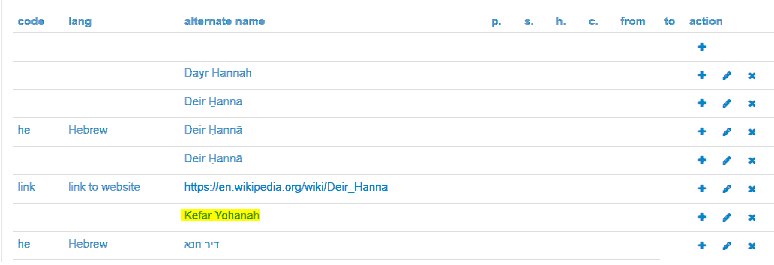
21. The course of Jachin: Kefar Yohana
In the Caesarea Inscription:

Current spelling: דיר חנא (Deir Hanna)
In Google Maps satellite ( N 32°51′43″ E 35°21′49″ )
In Google Maps satellite ( N 32°51′43″ E 35°21′49″ )
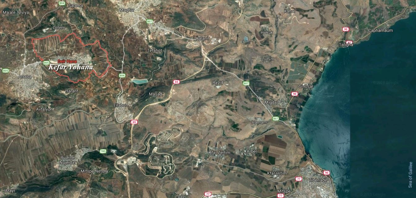
One of the etymologies of the present Deir Hanna is "Yohana or Hanun village which existed up until 732 BC and then again under the Byzantine rule." (Wikipedia)
Kefar Yohanah is an alternative name of Deir Hanna in Geonames.
Kefar Yohanah is an alternative name of Deir Hanna in Geonames.
22. The course of Gamul: Beth Hovaya
In the Caesarea Inscription:
22. The course of Gamul: Beth Hovaya
In the Caesarea Inscription:

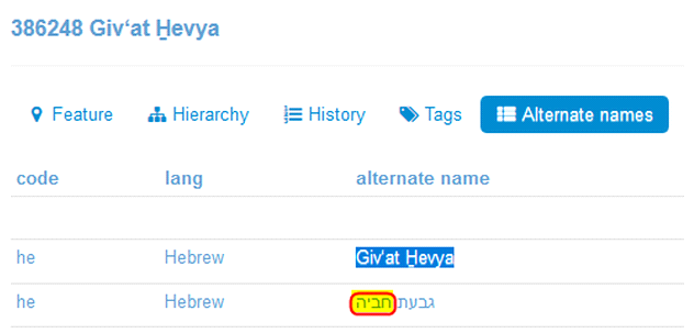
The city I suggest as Beth Hovaya ("house of Hovaya") is Giv'at Hevya ("hill of Hevya"). In Hebrew the spellings Hovaya and Hevya are identical: חביה
Current spelling: גבעת חביה (Giv'at Hevya)
In Google Maps satellite ( N 32°52'37" E 35°25'24" )
Current spelling: גבעת חביה (Giv'at Hevya)
In Google Maps satellite ( N 32°52'37" E 35°25'24" )
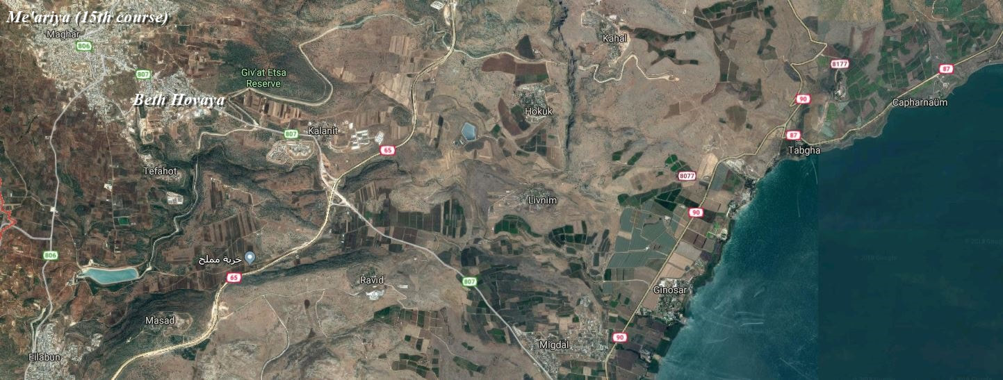
It is close to Maghar, which is Me'ariya, the 15th course.
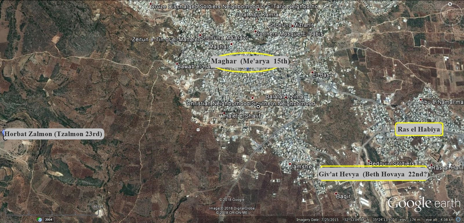
Close to Giv'at Hevya, there is Ras el-Habiya, an Arab place. The pronunciation is very similar to Hevya.
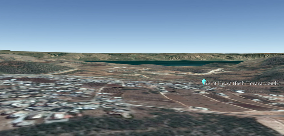
A Google Earth 3D view of the Sea of Galilee, from the hill of Ras el-Habiya and Giv'at Hevya.
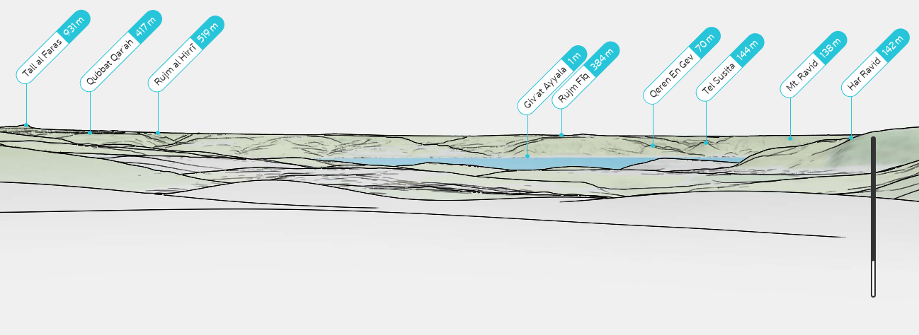
The same view, PeakVisor presentation
Hovaya/Hevya, the same spelling:
- In Geonames, Giv'at Hevya:
- In Geonames, Giv'at Hevya:
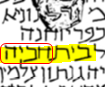
- In the 24 courses list, Beit Hovaya:
Geographically, the Arabic word Ras does mean 'promontory', 'headland', or 'cape'. Ras el-Habiya is a hill, hence promontory, as for the Hebrew Giv'at (hill) Hevya.
(In Hebrew, אברם = Abram or Avram, and אברהם = Abraham or Avraham. (See Gen 17:5 - OJB version), but the "v" sound does not exist in Arabic, only for words of foreign origin, but the similarity between Hevya and Habiya is evident.)
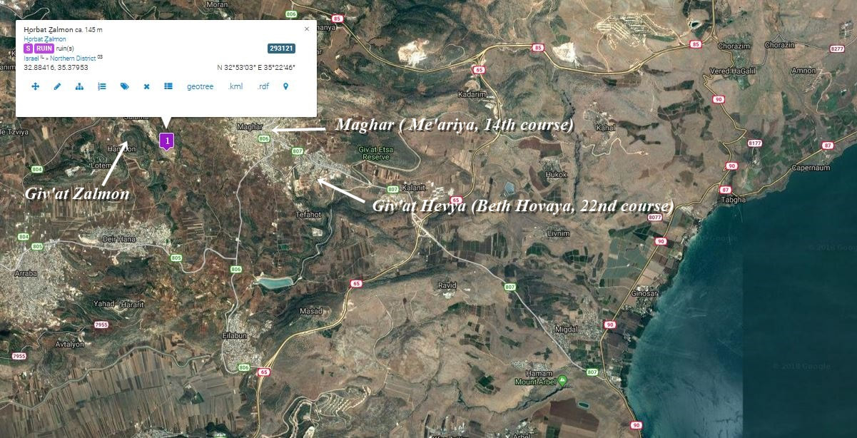
23. The course of Delaiah: Tzalmon
In the Caesarea Inscription:

Current spelling: צלמון
In Geonames ( N 32° 53' 3'' E 35° 22' 46'' )
In Geonames ( N 32° 53' 3'' E 35° 22' 46'' )
24. The course of Maaziah: Hamat Ariah
In the Caesarea Inscription:

Current spelling: חמת (Hammat)
In Google Maps satellite ( N 32°46′00″ E 35°33′04″ )
In Google Maps satellite ( N 32°46′00″ E 35°33′04″ )
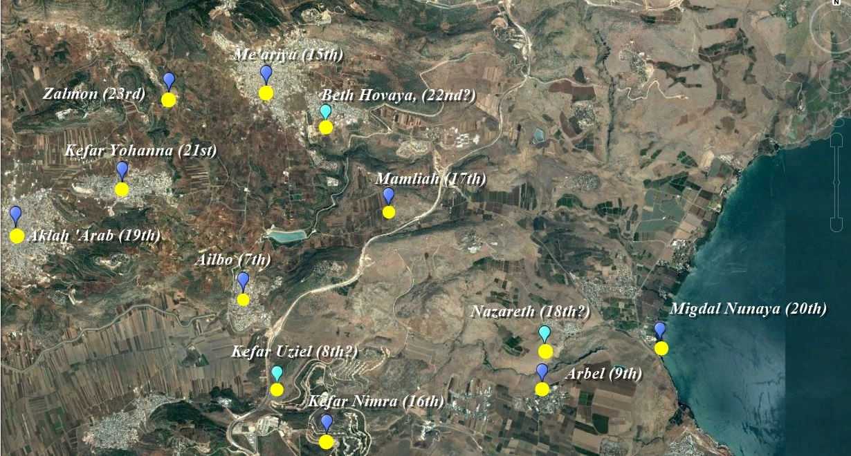
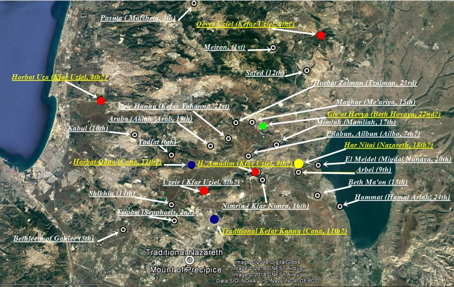
Clusters of Priestly Courses
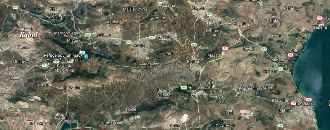
As seen in the map further above (8. The course of Abijah: Kefar Uziel), Qever Uziel, which means 'tomb of Uziel', is located to the north of Safed and east of Meiron. If it is not in relation with the 8th course Kefar Uziel (or Kefar Uziah), we have, with the certainty of Khirbet Qana as being the 11th course, 6 localities of the list, from the 6th through to the 11th, gathered as a cluster in an arc of a circle. There are 2 theoretical sites for Kefar Uziel: Horbat Uza, northwest of Kabul, and Horbat Amudim, west of Arbel. I propose Uzeir as well, which is south of the Netofah valley, as another potential site. (see map below)
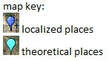
(orange dotted lines are the relations (not in any order) between the different theoretical sites of Kfar Uziel and other cities of the cluster)
- the 6th course: Yodfat,
- the 7th: Ailbo,
- the 8th: Kefar Uziel (read Kefar Uziah in the Hebrew list),
- the 9th: Arbel,
- the 10th: Kabul,
- and the 11th: Cana.
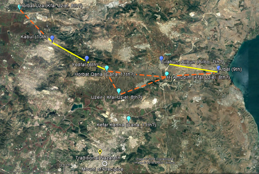
With Giv'at Hevya as Beth Hovaya (see further above: 22. The course of Gamul: Beth Hovaya), we find three courses following each other in numerical order: the 21st, 22nd, and 23rd, which are Kefar Yohanna, Beth Hovaya, and Tzalmon, respectively, all together in the same area:
- the 7th: Ailbo,
- the 8th: Kefar Uziel (read Kefar Uziah in the Hebrew list),
- the 9th: Arbel,
- the 10th: Kabul,
- and the 11th: Cana.
With Giv'at Hevya as Beth Hovaya (see further above: 22. The course of Gamul: Beth Hovaya), we find three courses following each other in numerical order: the 21st, 22nd, and 23rd, which are Kefar Yohanna, Beth Hovaya, and Tzalmon, respectively, all together in the same area:
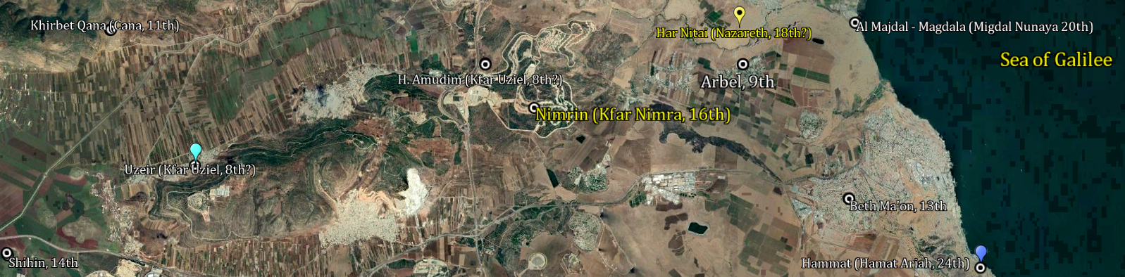
With Har Nitai as Nazareth, the 18th course, and Giv'at Hevya as Beth Hovaya, the 22nd, we have 9 priestly courses in numerical order in the same cluster, from the 15th through to the 23rd (in yellow dots on the map below).
Far southwest (not seen on the map), we can situate Shihin, the 14th course, from which begins a zigzag line, along which are the following priestly courses in numerical order (blue dotted line) through to the 18th, Har Nitai as Nazareth.
And from the 18th to the 23rd, another zigzag line again, the locations still following each other in numerical order (yellow dotted line).
- the 14th course, Shihin,
- the 15th, Me'ariya,
- the 16th, Kfar Nimra,
- the 17th, Mamliah,
- the 18th, (Har Nitai) Nazareth,
- the 19th, Aklah Arab,
- the 20th, Migdal Nuniya (Magdala),
- the 21st, Kefar Yohana,
- the 22nd, (Giv'at Hevya) Beth Hovaya,
- and the 23rd, Zalmon.
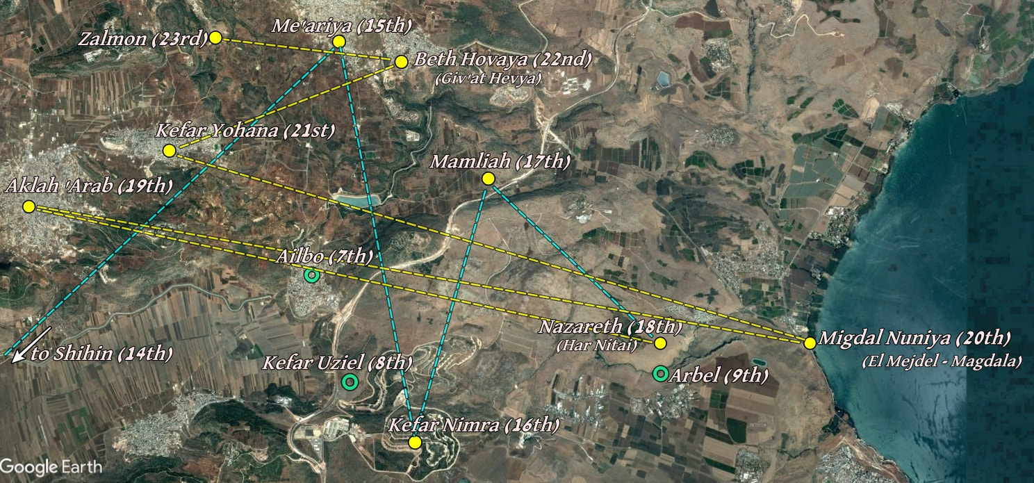
When one considers the sequence of priestly courses localities from the 14th through to the 23rd, two zigzag lines can be seen when an imaginary path heads for these places in numerical order. This singular plan, established by the priests when they came to settle in the Galilee, from the 14th to the 18th course, eastwards, and from the 18th to the 23rd, northwards,
would be a very odd coincidence, when Har Nitai is included as the 18th priestly course, Nazareth, and Giv'at Hevya
as the 22nd, Beth Hovaya. (From the 6th to the 11th, which are clustered altogether as well, we can notice here the 7th, 8th, and 9th. [see the first picture of this present chapter].)
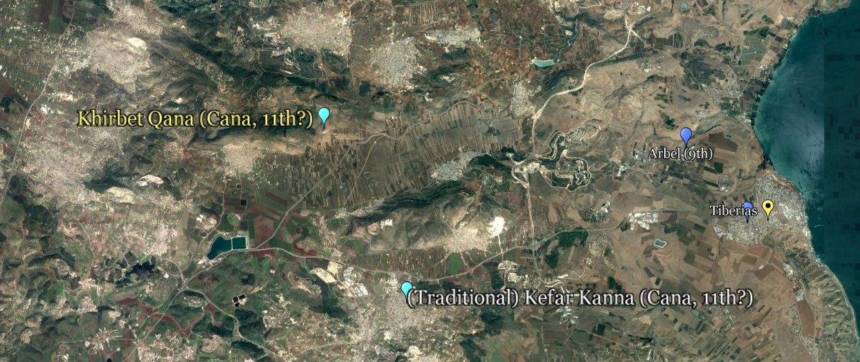
Biblical sites with same latitude in Galilee . . . .
As well, Khirbet Qana (as Cana in Galilee - Qana, the 11th priestly course), Har Nitai (as Nazareth, the 18th), and El Mejdel (as Magdala, perhaps the hometown of Mary Magdalene - Migdal Nuniya, the 20th), are situated at about the same latitude.
- Cana of Galilee, the hometown of Nathanael, where Jesus changed water into wine and healed from that place the son of a royal official who was in state of illness at Capernaum, is mentioned 4 times in Scripture. These were the two first miracles of Jesus recorded in the Gospel of John.
- Nazareth, the former hometown of Jesus, 12 times. (Some other verses wrongly translate, depending on biblical versions, "of Nazareth" the original Greek names Nazōraiou, Nazarēne, Nazarēnos, Nazarēnou, Nazōraion, and Nazōraios, which mean "Nazarene", an inhabitant of Nazareth. We can have a look, for example, in Matthew 26:71, among other verses, the right translation (Jesus the Nazarene) and the wrong (Jesus of Nazareth) through 60 biblical versions. As well, in John 1:45, we should read "Jesus, son of Joseph, from Nazareth", and not "Jesus of Nazareth, son of Joseph", seen in several biblical versions. The name 'Nazarene' is used 12 times as well, when the version respects the original, of which 11 times in relation to Jesus, and once for 'the Nazarenes', in Acts 24:5.
- Mary (the) Magdalene, from which Jesus drove away seven demons, 12 times. (The name Magdala is not mentioned.)
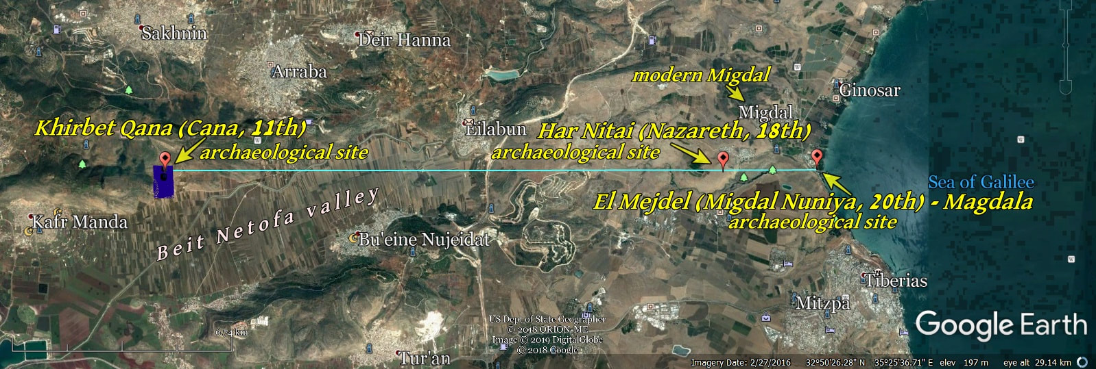
The blue area represents the whole hill of Kh. Qana.
We know that Nathanael came from Cana " ... and Nathanael of Cana in Galilee ... " (John 21:2), and we know about his words, “Can any good thing come out of Nazareth? " (John 1:46). It is obvious, when one is certain of the identity of Khirbet Qana as being 'Cana in Galilee', that he did not speak of the traditional Nazareth, which is far away southward, but rather of a place he usually passed nearby, or at a short distance from, such as the present Mount Nitai, and per-haps close to Magdala as well, when he went to join the other disciples at the Sea of Galilee.
. . . . and this latitude continues on its course to the other side.
Eastwards, across the Sea of Galilee, at the same latitude, is located the place with the steep bank from which two thousand swine rushed down and drow-ned in the sea, when Jesus removed evil-spirits from two men into them, in the country of the Gadarenes (Matthew 8:28-34). It is next to the modern Kursi, an archaeological site known as the traditional place about this event.
(Mark 5:1-20 and Luke 8:26-39 speak of one man, and the country, or region, of the Gerasenes. In fact, the place of this miracle belonged to the country of both Gadara (the modern village of Umm-Qeis), 12 miles/19 km south of the place of this event, and Gerasa (the modern Jerash), which is 40 miles/65 km south-southeast of the same place. Each of these two cities was counted among the 10 cities of the Decapolis, which was for the most part in present-day Jordan. Matthew chose to mention Gadara ("country of the Gadarenes"), Mark and Luke chose Gerasa ("country of the Gerasenes"), according to different points of view, or periods when they wrote the gospels. Hippos, also called Hippus or Sussita, was one of the 10 cities of the Decapolis as well, and closer to the place of the event, and certainly had Kursi under its jurisdiction. Kursi was at the northern limit of the region of Gadara, as we can see in several histori-cal maps.)
"When He came to the other side into the country of the Gadarenes, two men who were demon-possessed met Him as they were coming out of the tombs. They were so extremely violent that no one could pass by that way." Mat. 8: 28
"They came to the other side of the sea, into the country of the Gerasenes. When He got out of the boat, immediately a man from the tombs with an unclean spirit met Him, and he had his dwelling among the tombs. (...)" Mark 5: 1-3
" Then they sailed to the country of the Gerasenes, which is opposite Galilee. And when He came out onto the land, He was met by a man from the city who was possessed with demons; (. . .)" Luke 8: 26,27
"The demons began to entreat Him, saying, “If You are going to cast us out, send us into the herd of swine.” And He said to them, “Go!” And they came out and went into the swine, and the whole herd rushed down the steep bank into the sea and perished in the waters." Mat. 8: 31,32
It is said that Kursi "is the only place fitting Matthew's description, since it contains the only "steep bank" in the area descending all the way to the shore of the lake" https://en.wikipedia.org/wiki/Gergesa
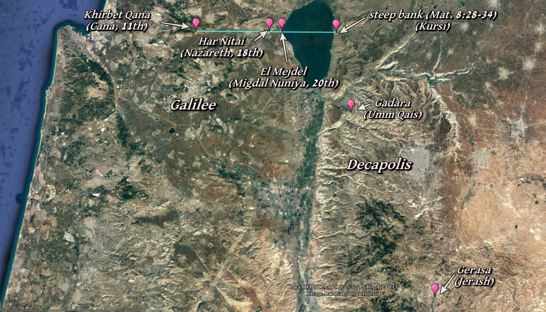
The meaning of Decapolis is "ten cities". Gadara and Gerasa were two of these.
The fact that there were swine shows the evidence of a Gentile place.
The fact that there were swine shows the evidence of a Gentile place.
|
From Wikipedia, "Dr. Michael Avi-Yonah (September 26, 1904 – March 26, 1974) was an Israeli archaeologist and historian. During his career he was a Professor of Archaeology at the Hebrew University of Jerusalem, and served as secretary of the Department of Antiquities as well. Biography Born in Lemberg, Austria-Hungary (today Lviv, Ukraine), Avi-Yonah moved to the Land of Israel with his parents in 1919 during the Third Aliyah. He first studied at Gymnasia Rehavia in Jerusalem, then he went to England and studied history and archeology at the University of London. Upon his return to the Land of Israel, he studied at the British School of Archaeology in Jerusalem. His first archaeological excavations were at Tel el-Ajjul, near Gaza, and Jerusalem Ophel.[2] At the end of his studies, he joined the Department of Antiquities of the British government of Palestine. He worked as a librarian and archivist. After the independence of the state of Israel, he became secretary of the Department of Antiquities. In 1949, he conducted excavations at Givat Ram in Jerusalem during the construction of the International Convention Center, where he was the first to discover a brick factory of the Legio X Fretensis. He participated in the first survey that preceded the Masada excavations, and conducted a limited excavation north of Caesarea Maritima where he discovered an ancient synagogue. He was awarded the Bialik Prize in 1955 for his book Antiquities of our land. Avi-Yonah died in Jerusalem in 1974." Wikipedia - Avi-Yonah |
From academia.edu - Nazareth, the Caesarea Inscription and the Hand of God
"The fragment A of the Caesarea inscription touch on four lines of text. When we compare that text with the four lines above we find an absolute identity as regards the letters appearing on the fragment. This shows that Avi Yonah did not take any liberties in interpreting the inscription, simply because the reconstruction is not his at all—it is that of Samuel Klein set forth more than twenty years before the discovery of the Caesarea inscription. Avi Yonah writes:
The key to the understanding of the inscription is to be found in fragment 1 [=Fragment A]. If we compare the text with the list of the priestly courses, as established theoretically by Prof. Samuel Klein - together with their appellations and the names of the villages in which they lived in Galilee, the identity is astonishing. [Vardaman, J. and Garrett, J.L., The Teacher’s Yoke, Waco, Texas, 1964.]
Thus, the Caesarea inscription, fragment A, discovered in 1962 apparently irrefutably demonstrates the correctness of Samuel Klein’s reconstruction, and implies the existence of a Galilean village with the name Nazareth at least from the second half of the second century CE."